
Definition of Regioplolis
Regiopolis is a term of land use and urban planning which is composed of Regio (region) and polis (city). Currently this perception, which was developed in 2006 as a work-concept of the University of Kassel for a new research and the politics field, describes smaller cities beyond metropolitan areas. Moreover these regiopolises function as centers of regional development, areas of the knowledge-based society and as a centre of attraction for their mostly rural region. It is always a matter of regional centers that play a special role for the region, especially in a supplying and balancing manner. But they do not reach the status of a metropolis due to their smaller size and thus can be characterized as the” little sisters” of the metropolises. Similar to a metropolitan region, the region surrounding a regiopolis is also referred to as “regiopolis region”.
An approach to identifying potential regiopolises in Germany
 |
To identify potential regiopolises in Germany, Prof. Jürgen Aring and Prof. Iris Reuther of the university of Kassel gathered various criteria, which are supposed to be explained below (source: Aring/ Reuther (2008): Die Regiopole – vom Arbeitsbegriff zur konzeptionellen Idee):
- Population either of the core city or of the urban network with over 100,000 residents
- Location beyond of a metropolitan region
- potential of knowledge and innovation (measured from the status as a location of a university or a large technical college)
In total 82 of the German bigger cities were considered in terms of the criteria mentioned above. 19 of these core cities qualified as a metropolis region and another 30 are located in a metropolitan area. The remaining 33 cities have been regarded with the theory of gravity i.e. the cities were classified according to the parameters of mass and distance.
- Mass (demographic and economic weight) Population accessibility approach: Total population of all municipalities within a distance of 100km around the core of the city in dependence to the traveled distance. The weight, in which the community population in the area is included, decreases with an increasing distance every ten kilometres by the half. Therefore cross-community action space and opportunities for mobility of the residents are considered. Metropolitan functions indicator: The indicator is subdivided into established indicator groups such as decision and control functions, innovation and competition performance, the gateway function and the function as a symbol (the last ones since 2006) to measure the metropolitan power.
- Distance: The distance to the cities classified as metropolitan cores is measured by the cars driving route.
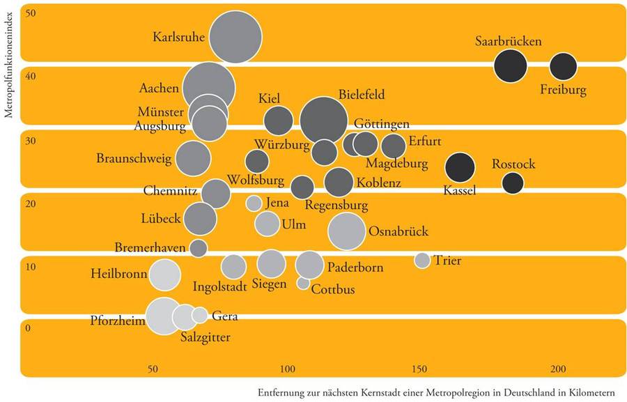
According to that, the bigger its mass and spatial distance from a metropolis, the greater is the potential of a city to be a regiopolis. A chart to identify regiopolises in Germany results in order to the described parameters above. The x-axis illustrates the distance to the nearest urban core of a metropolis area. Meanwhile the y-axis reflects the extent to which the cities undertake metropolitan functions and the size of the circles correspond the to the region’s population potential in the interior of Germany.
Based on this study, four groups can be classified in terms of distance to the nearest metropolis and the size of the metropolitan function index:
- Group 1: distance ~ 200 car kilometers (prototype); metropolitan function index above average
- Group 2: distance 90-140 car kilometers; metropolitan function index above average
- Group 3: distance 90-140 car kilometres; metropolitan function index below average
- Group 4: distance 50-75 car kilometres (special relation to metropolitan regions)